http://etcjournal.com/2013/07/23/esri-2013-the-best-conference-ive-attended-this-year/
This article originally appeared in the ETCJournal.
Esri 2013 – The Best Conference I’ve Attended This Year

The absolute best conference that I have attended this year is the Esri Educators Conference, San Diego, July 6–9, 2013. Note that the educators also participated in the main conference, Esri International User Conference, also in San Diego, July 8–12, 2013. The big conference is also online.
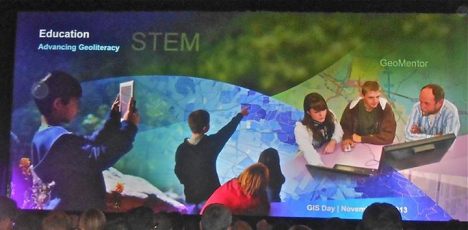
This photo captures the essence of the Esri Education GIS (geographic information system) Conference.
In the days before the main conference, the educators’ conference is one of many mini-sessions. These groups quietly gather in separate meeting places. They are long enough to be meaningful.

The educator’s conference is different from any other conference I have attended. It is small and intimate. The icing on the cake for this conference was that six educators were picked from their videos to tell their GIS stories. They shared them and freely interacted with the audience. The stories were moving, diverse and informative.
There was plenty of time after the sessions ended for meetings and networking. This conference allows one to meet professors, to network with other teachers, national and international, and to gain practice in GIS skills with hands-on sessions and guidance. We had an un-conference section. There were also educator blogs and skill workshop sessions.
Each session was threaded with involved Esri staff. It was more diverse this year in many wonderful ways, the presentations reflecting real world use of GIS, and opportunities for those of us who want to do more and to be able to teach specific topics. I learned how to do more and am thinking about more study in this field. I was pleasantly surprised to network with people, educators from around the world and the U.S., with my interests in helping minorities to learn about GIS.
The Main Esri Conference
Esri is modified each year. I attended last year and thought, since it was new to me then, this time might not be as interesting. I was wrong. There were three things this year that caught my attention. I liked this introduction to online ESRI which came before the conference:
We built a website just for you, the GIS Professional.
We’re excited to let you know about a new website we’ve built for you. It’s called ArcGIS for Professionals and it’s a single destination for everything you need to get the most out of your GIS.
ArcGIS for Professionals is your go-to resource in 8 key areas:
Mapping, Analysis, Going 3D, Managing Your Data, Sharing Your Work, Planning Your Projects, Enabling your Enterprise, Customizing Your GIS
Meet your new website. ArcGIS for Professionals.
I can’t highlight a whole day, but I can share the background and description of those who were the main speakers. Jack Dangermond shared the ideas of the main speakers with us.
Sam Pitroda: I lived in India (Fulbright) so I was mesmerized by a plan on how to transfer technology to the whole country. It was done visually and with major strands of ideas. Esri described the speaker Pitroda as the advisor to the Prime Minister of India on Public Information Infrastructure and Innovations with a rank of cabinet minister. He plans to use GIS to transform telecommunications, infrastructure, and the relationship between government and its citizens.
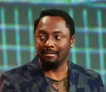
will.i.am
Will.i.am: On one occasion, will.i.am was beinginterviewed (look down the page and to the right), and he got emotional. So did I. I really did not know who will.i.am was. I loved his story. You have to look at the interview to see how gripping it was, at least for me. I don’t cry easily. I am usually not too impressed with celebrity spokespeople. Who is will.i.am? William James Adams, better known as will.i.am, is an American recording artist, songwriter, entrepreneur, voice actor, DJ, record producer, and philanthropist, best known as one of the founding members of the hip hop/pop band, The Black Eyed Peas (Wikipedia).
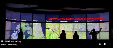
Urban Observatory
3. Urban Observatory is a project that has it’s own page on the Internet and a video that explains it. There are these pictures. Here is how they describe it: “A live museum with a data pulse. You’ll have access to rich datasets for cities around the world that let you simultaneously view answers to the most important questions impacting today’s global cities — and you. Compare and contrast visualized information for a greater understanding of life in the 21st century.”

The first day is a plenary. Last year, when I heard that it lasts all day, I thought, What? They must be kidding!
I am sure I made a face, but it is an all day affair that you do not want to miss! It may be harder to sit at home and watch the video. We did a lot of networking during the breaks, and the breaks were unusual: two hours for lunch and time to go to the bathroom. The sharing was excellent. People in the audience were encouraged to share and network.
You could experience the conference from a gathering of comfortable white couches, or a platform of desks, with a place to plug in your computer — or you could sit in the regular chairs that most conferences provide. There were huge screens to make sure that you didn’t miss anything. The graphics and visuals were outstanding. There were some beanbag-type chairs. I did not see them until later. I went for the couch. It was comfortable.
Why go to the conference if you can attend it online? You make the choice.
I would not like to miss the in-person parts of this conference. I did also enjoy a presentation by the Philadephia police, who showed how mapping a criminal’s movements helped them capture and put him away.
Hands-On in the Education Conference
There are all kinds of workshops to teach you the real applications, one on one. You can test products that you do not have and gain new skills and techniques. You can use their computers. I like it that you were able to talk to and question the people who developed the various applications. There are also professors who are skilled in GIS, and they share their work. I learned about another gathering of educators that I want to be a part of.
One of the people who told her story reminded me of myself. She wanted to be in show business and got sidetracked by GIS. So interesting a story.
I have invaluable links to share with educators in my work.
The MAP Gallery
This is an evening experience in which there are many, many maps on exhibit. There was a kind of a competition to identify some places, and there was food, food, food and then some. We walked about in the map gallery and networked. There are numerous photos at this link.

Participants came from many places in the world.
I think I want to be an urban educator who shares the vision of Esri with students and teachers and communities in ways that make it personal.
It is not because will.i.am cried and shared his personal story. But it was a touching moment. I have often wondered why people do not go back to the place that they came from, to make it better. I remember will.i.am’s neighborhood. I was working in a technology truck that went all over the country. I taught Kindergarten kids physics, honestly, with the help of Bell Lab professors, and they loved it. When we were leaving the school, the kids were so upset that they threw rocks because they wanted to prevent us from leaving. I exited the technology truck and talked to the kids. I often wonder why celebrities do not engage in the places where they lived.
Final thoughts: There is incredible coaching at Esri, and the opportunity to learn in new ways based on your particular interests or to collaborate with others. On the EXPO floor, groups shared their work, invited others to see, be employed, and know their best projects. So many groups, but there were days of time to comfortably review the exhibits.